
Southcourt Map
Map of Southcourt - Here is a map of the Southcourt area of Aylesbury in Buckinghamshire.
Map of Southcourt Aylesbury
Southcourt Map: Above you can view a map of Southcourt, a housing estate and area of Aylesbury in Buckinghamshire.
Southcourt was built in the 1920's and 1930's and its construction was halted by World War 2. It was build on a former pig farm of the same name and the first sod was cut by the Duke of York in 1922. Southcourt's oldest house is in Cottesloe Road. The first homes were occupied by veterans from the First World War.
Visible on this Southcourt map are: Churchill Avenue, Prebendal Avenue, Grenville Road, Carrington Road, Cottesloe Park, Thrasher Road, Penn Road, Nightingale Road, Birch Court, Cottesloe Road, Freemantle Road, Russell Avenue, Chalgrove Walk, Oak Green, Hampden Road, Mandeville School, Stoke Mandeville Hospital, Stoke Mandeville Stadium and more.
Zoom in (+) to get even more detail.
Google Street View of Southcourt Aylesbury
Above you can see a Southcourt street view (Google), showing Churchill Avenue and Hampden Gardens.
Old Photos of Aylesbury - Southcourt - The Steeplechase Pub
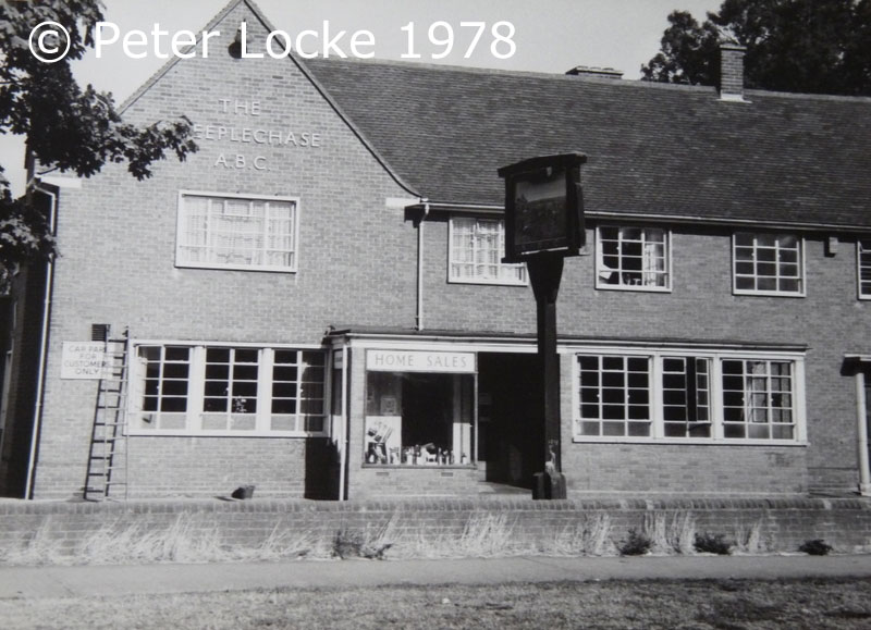
Old photo of the Steeplechase pub in Southcourt, Aylesbury. Taken by Peter Locke in the 1970's. Sadly this pub is now demolished, one of the many.
- Aylesbury Town Centre Map
- Aylesbury College
- Bedgrove Map
- Map of Bierton
- Map of Hartwell
- Map of Watermead
- Fairford Leys
- Southcourt Tilers
- Churches Map
- Aylesbury Electricians
- Aylesbury Post Offices
- Stoke Mandeville Hospital
- Church of the Good Shepherd
More Old Photos of Aylesbury:
>>>>> BACK HOME
Southcourt Road Map - Southcourt Photos - Images of Southcourt